| visit-brecon-beacons.co.uk |
The Date is
Sunday, 28-Apr-2024 20:21:01 CEST
Brecon Beacons National Park |
|
||||
| YOU ARE HERE > Home Page > Brecon Beacons National Park |
|
||||||||
|
||||||||
 |
||||||||
|
||||||||
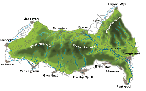
The Brecon Beacons National ParkThe park is located in mid-Wales in the UK was established in 1957, under the National Parks and Access to the Countryside Act of 1949. It was the tenth area in England and Wales to be given such status. The Brecon Beacons National Park Authority has been awarded the British Horse Society (BHS) Access Award for the National Park most active in opening up equestrian routes. A perfect riding resort with spectacular scenery, wealth of wildlife and some of the best riding in Europe. The landscape of the Brecon Beacons has recently been officially recognised as one of the most important geological areas in Europe. In October 2005, the Fforest Fawr Geopark within the National Park was awarded membership of the highly prestigious European Geopark Network and given UNESCO Global Geopark recognition. The Brecon Beacons is the first National Park in the United Kingdom to achieve Geopark status, and is also the first Geopark in Wales. Situated between south and mid-Wales, in the United Kingdom, the Brecon Beacons National Park contains some of the most spectacular and distinctive upland formations in southern Britain covering an area of 1347 sq km (520 sq miles). |
|||
 |
|||
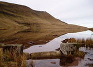
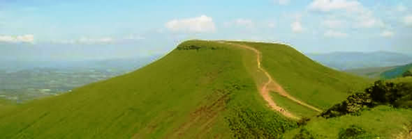
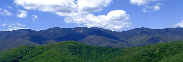
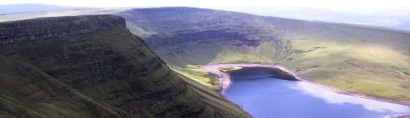
In the east of the Park are the Black Mountains, with a high point of 811 metres at Waun Fach. They also form a natural border with Herefordshire, in England. The Central Beacons dominate the skyline to the south of the town of Brecon and rise to 886 metres at Pen y Fan, the highest point in southern Britain. Further west lies the sandstone massif of Fforest Fawr, comprising a series of hills known as 'Fans', with Fan Fawr being the highest point at 734 metres. Water rushing southwards from this area has formed steep river valleys with spectacular waterfalls. The most westerly block of sandstone is Y Mynydd Du, The Black Mountain, culminating in the summit of Fan Brycheiniog at 802 metres and contains the two enchanting glacial lakes of Llyn y Fan Fach and Llyn y Fan Fawr. |
|||
 |
|||
| Two thirds of this area is comprised of Old Red Sandstone rocks. They form four distinct blocks of hills which are cut through by major river valleys, such as the Honddu, Grwynne Fechan and Fawr, Usk, Taf Fechan and Fawr, Hepste, Mellte, Nedd, Tawe, Twrch and Sawddee. |
|||
 |
|||
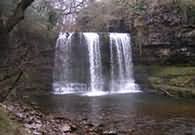
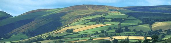
| Along the southern edge of the National Park the geology alters, and outcrops of limestone and millstone grit predominate. The limestone scenery contains many ridges and screes and in some areas the land is pockmarked with hollows known as shakeholes of swallow holes. Beneath the surface there are magnificent caves and passages, often adorned with stalagmites and stalactites. The millstone grit produces a tough, rather sombre landscape which is often waterlogged but is largely responsible for the formation of the famous waterfalls area of the Park. |
|||
The landscape of the Brecon Beacons National Park is largely the product of human intervention stretching back over many thousands of years. Around 5500BC in Middle Stone-Age times, hunter-gatherers cut down scrub and burned the aftermath in an attempt to create small grassland areas to encourage the grazing animals which they hunted. In the New Stone-Age farming was introduced to the area and, by the close of the Bronze-Age, significant forest clearances had occurred. During the Iron-Age, Celtic peoples settled in the area bringing increased sophistication to farming methods. They erected hill-forts of which impressive banks and ditches remain today. The Roman occupation left a legacy of an improved communications infrastructure and 12th century Norman patterns of land-use are still evident today. The Middle Ages saw the consolidation of the Norman manorial system, but there were cataclysmic episodes such as the Black Death and the Glyndwr Revolt. From the end of the fifteenth century onwards industries such as ironmaking, charcoal, limestone extraction and coal mining began to be established in the area. There is a rich industrial archaeology to be found to the south and east of the Park. Some hillsides, such as those above the Clydach Gorge and on the Cribarth Mountain, have been altered considerably by industrial development which continued into the twentieth century. More recently, urban expansion, road building, construction of canals and reservoirs, erection of power lines, large conifer plantations and changes to agricultural practices have all contributed to the ever changing environment of the National Park. |
|||
Tourism and Recreation There is something for everyone here, whether you are an expert or a beginner, someone wanting the thrills of mountain challenges or just the rewards of getting out into the fresh air. You can quietly explore the area on foot, bike or horse, ascend the highest peaks or throw yourself into mountain biking, caving or gliding that is as challenging as any in the country. Sailing, climbing and canoeing are catered for, whilst followers of golf or fishing can find plenty with which to occupy themselves. The vast majority of visitors to the Brecon Beacons National Park, arrive by private vehicle, with 'scenery and landscape' being the most often quoted reason for visiting. Visiting caves and for the more expert, exploring them, is a popular activity.
Not surprisingly, 'sightseeing by car' is the most popular activity for visitors and of the
more active pursuits, walking is the most popular, but cycling, caving, water-sports, trekking
and fishing are also widely enjoyed. The rich natural and built heritage of the National Park is also a source of pleasure for the many visitors who enjoy bird-watching, painting, photography, visiting archaeological and historical sites and shopping.
|
|||
|
|||
The Brecon Beacons National ParkDesignated a national park in 1957. The Brecon Beacons National Park is situated in mid-Wales. It contains some of the most spectacular and distinctive upland formations in southern Britain, The park occupies 519 sq miles (1,344 sq km) of mountains, moors, forests, pastureland, lakes, and the broad Usk valley. The easternmost highlands in the park, lying between Abergavenny and Hay-on-Wye, are the Black Mountains (old red sandstone) - highest point Waun Fach (2,660 ft [811 m]). Centrally located within the park, south of Brecon, are the Brecon Beacons (old red sandstone) including Pen-y-Fan (2,906 ft [886 m]), the highest peak in the park. To the west lies the Black Mountain (chiefly millstone grit). The park offers a considerable variety of scenery and recreational opportunities, including hill walking, caving, pony trekking, sailing, and angling. This amazing landscape has now been officially recognised as one of the most important geological landscapes in Europe. In October 2005, the Brecon Beacons National Park Authority was awarded membership of the highly prestigious European Geopark Network and given UNESCO Global Geopark recognition for the Fforest Fawr Geopark. |
|||
|
|||
The Park ranges from Llandeilo in the west to Hay on Wye in the east which contain a wide variety of spectacular scenery, with mountains, waterfalls, lakes and caves. The Brecon Beacons is home to many species of bird life and wild plants. Abergavenny is a small market town in Monmouthshire (formerly Gwent) in south east Wales, at the confluence of the Rivers Gavenny and Usk and on the edge of the Brecon Beacons National Park. The strategic nature of this site, guarding a main valley corridor between the Black Mountains and the Brecon Beacons into South Wales, was recognized by the Romans, who built the fortress of Gobannium, and by the Normans, who built an 11th-century castle. The town that grew under the castle's protection was attacked at various times over the next 500 years. Abergavenny held important cattle and horse fairs in the 18th and 19th centuries and developed some flannel making; it never participated in the industrial growth of the coalfield towns to the west. Now a service centre and attractive holiday resort, it has also become a residential base for commuters employed in South Wales and nearby England. Abergavenny can be used as a base for many delightful walks. |
|||
 |
|||
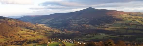
Sugar Loaf Mountain, usually called simply the Sugar Loaf (Welsh: Mynydd Pen-Y-Fal or Y Fâl), is a mountain situated north-west of Abergavenny in Monmouthshire, Wales. One of the Black Mountains, its height is 596 metres. A Sugar Loaf foothill, Y Graig, was discovered in the 1990s to be the site of prehistoric flint tools dating from the Mesolithic, Neolithic and Bronze Age.The Sugar Loaf is very popular with walkers. A vineyard, producing Sugar Loaf wines, is situated at Dunmar Farm at the foot of the mountain. |
|||
 |
|||
The Black Mountainsare a group of hills in south-eastern Wales, and a small part of Herefordshire, England. They are the easternmost of the three groups of hills that are covered by the Brecon Beacons National Park, and are frequently confused with the westernmost, which are collectively called the Black Mountain. (To confuse matters further, there is a peak in the Black Mountains called Black Mountain.) They may be roughly defined as those hills north of Abergavenny, south of Hay-on-Wye, east of the A479 road (the Rhiangoll valley) and west of, or on, the English border. The Offa's Dyke long-distance footpath runs along the border. The area is popular with hillwalkers and pony trekkers.There are few villages in this area and one youth hostel, at Capel-y-ffin. The Skirrid Inn also has a wider reputation, being claimed as the oldest Public House in Wales. Antiquities include Llanthony Priory, Tretower castle and court, the Iron Age hill fort Crug Hywel, and Castell Dinas, an 11th- to 13th-century castle. The highest mountain in the group is Waun Fach (811 m); other mountains include the Sugar Loaf, Ysgyryd Fawr, Mynydd Troed, Graig Syfyrddin, Allt yr Esgair, Myarth, Mynydd Llangorse, Bryn Arw, and Black Mountain. Ysgyryd Fawr is also known as the Skirrid, Skyrrid or 'Holy Mountain'. |
|||
 |
|||
The Black Mountainis a mountain in the Black Mountains (not to be confused with the Black Mountain range of hills). It is the only hill to fall exactly on the Welsh-English border, straddling Powys and Herefordshire.Offa's Dyke long distance footpath passes along the ridge, more or less from south to north (or vice versa), while a steeper path leads to the summit from near the youth hostel in the Vale of Ewyas to the west. It is the highest ground in England south of the Yorkshire Dales, even though higher neighbours are very close by in Wales. |
|||
Mountain rescue in Wales is provided by seven groups, with assistance from local Police, and in serious situations an RAF helicopter from RAF Valley. These are:
Most are staffed by local volunteers and funded primarily by donations. Their work is not restricted to mountain and wilderness rescue; often teams are utilised by the local police to search for missing or vulnerable persons in the community. |
|||
Towns and Villages in the Brecon Beacons
|
|||
|
|
|||
|
|
|||
Tourist Information Guide for the Landscape of the Brecon Beacons |
|||
| This page last modified Friday, 12-Jul-2019 12:32:13 CEST | |||